


Spatial analysis of social segregation
![]()
The uniqueness of residential areas with their urban structural and social dimensions is normal and at the same time an interesting part of everyday life and urban culture. However, the accumulation of social disadvantages resulting from the strong structural, socioeconomic and demographic segregation to certain areas, is considered a problem for which mitigating measures have been sought around the world.
At Ubigu, we have developed a spatial data-based analysis model to map and visualize the development of city-specific segregation. The model can be used to map the level of segregation and its progress down to a block level, in the long term increasing understanding of the effectiveness of for instance mitigating urban planning measures.
The ultimate purpose of analyzing segregation is to ensure that all people have sufficiently equal opportunities for well-being and a prosperous life, and that urban planning and provision of public services do not, in any case, reinforce undesired segregation. Ubigu has developed a spatial data processing and analysis method for monitoring the development of segregation in residential areas during the past few decades. The method has been applied in several large cities and is based in particular on long-term research on urban-level regional, socioeconomic and social segregation (by researchers such as Vaattovaara and Vilkama).
The model developed by Ubigu is based on various indicators of urban development and spatial data related to these. Thematic analyses that reach the block level provide better support than traditional administrative boundary or zip code -based analyses for:
- studying residential segregation patterns and trends
- urban planning and decision-making
- planning of targeted support mitigatory measures
The most established indicators of socio-economic well-being are level of education, unemployment rate and income. If, in addition to socio-economic segregation, other aspects of segregation are to be examined, such as ethnic characteristics, other data sources can be added to the analysis.
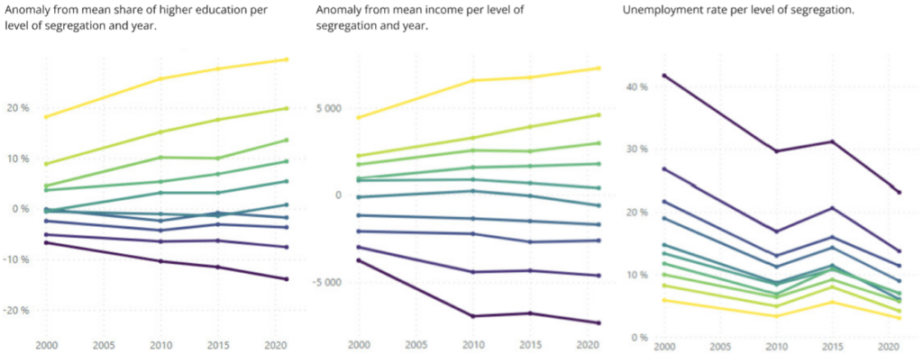
The focus of the analysis is typically on relative socio-economic segregation between residential areas, rather than absolute well-being. Development patterns of segregation area studied in relation to other factors such as:
- building types
- age of the building stock
- apartment types
- ownership or lease of aparments
- ethnic structure
We are able to illustrate the results achieved with a sophisticated automation-based analysis method both in traditional, visually clear one-timer reports, as well as in PowerBI-based interactive, map-based dashboards suitable for more continuous monitoring.
More

